Santa Elena Canyon, Big Bend National Park
- Visit in spring (March–May) or fall (September–November) when temperatures are most manageable. Summers run extremely hot with high temperatures throughout the day, and winters are generally reasonable but can turn cold, especially at night.
- The trailhead sits at the end of Ross Maxwell Scenic Drive. From the west entrance station, drive east on Panther Junction Road for 9 miles, then turn right onto Ross Maxwell Scenic Drive and head south for 30 miles to the Santa Elena Canyon parking lot.
- The trail crosses Terlingua Creek, climbs several short switchbacks, then descends along the Rio Grande, with 1,500 foot limestone walls rising on either side until the canyon walls finally meet the river. The out and back trail covers 1.3 miles and takes about 40 minutes.
- For a deeper look at the canyon, a raft or canoe trip is a strong option. Local outfitters run trips from one to three days in length when conditions allow, and intermediate or experienced paddlers often go on their own.
- Terlingua Creek can be impassable after rains, flash floods, or periods of high water, effectively closing the trail, so check with the park before you go. Cell service is very spotty throughout the park, with long stretches of no coverage, so download maps and come prepared.
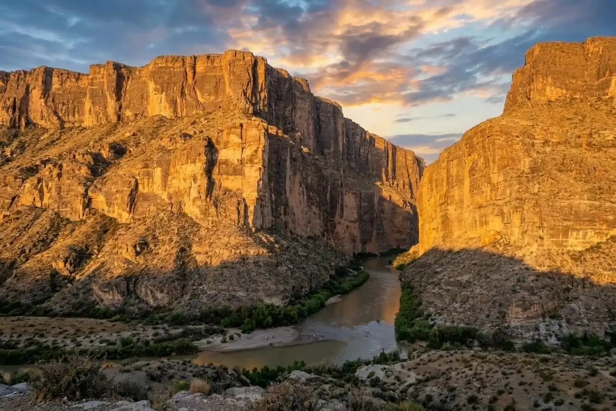
Standing at the trailhead at dawn, the limestone face of Santa Elena Canyon catches the first light while the interior stays in deep shadow. The Rio Grande flows out from that darkness past the mouth of Terlingua Creek, then spreads wide across the Chihuahuan Desert toward the horizon.
The canyon walls on both sides of the river rise more than 1,500 feet straight from the water, cut from dense limestone that formed as marine sediment between 60 and 130 million years ago when a shallow sea covered this part of Texas. That rock still holds marine fossils and calcite crystals visible from the trail, a record of a very different landscape.
At the canyon's mouth, prickly pear, ocotillo, and creosote bush grow in the caliche and rocky soil. Bluebonnets emerge in spring wherever moisture collects between the rocks. Javelina graze through this desert scrub at low light, peregrine falcons hunt the airspace above the river, and canyon wrens call from somewhere in the upper walls of the gorge.
Once you cross Terlingua Creek and enter the canyon proper, the temperature drops noticeably, the sky narrows to a strip overhead, and the enclosed walls amplify the sound of the river. The trail runs about 1.6 miles round trip and ends where the limestone walls descend directly into the water with nowhere left to walk.
This guide covers what to know before you arrive: the trail, the geology, the wildlife you're likely to encounter, and how river levels and seasons alter the experience.
Getting there
The trailhead sits at the end of Ross Maxwell Scenic Drive on the western side of Big Bend National Park. From Panther Junction, head west on the main park road for about 13 miles and turn south onto Ross Maxwell Scenic Drive. Follow it 21.9 miles to the end of the road, then turn right onto Santa Elena Canyon Road and drive 9 more miles to the trailhead parking area. From there, the trail begins on a boardwalk heading southwest toward the north shore of Terlingua Creek near its confluence with the Rio Grande. Plan on at least an hour of driving each way from Panther Junction.
When to go
October through April is the most favorable stretch for visiting this part of the park, keeping temperatures manageable and the light cooperative. Sunrise and sunset are the best times of day to be at the canyon to get soft, directional light on the walls. At sunrise the sun clears the Chisos Mountains to the east and sends direct light across the canyon mouth, bringing out the layered texture of the limestone in ways that midday light flattens. Late afternoon offers a second window when the last rays reach the south canyon wall from across the river. Spring is warm and pleasant and draws the largest crowds, while summer heat builds through May and August before fall transitions quickly into a cooler, quieter season.
Details worth slowing down for
The canyon walls hold more than scale. Look closely at the limestone on the switchback section of the trail and you'll find fossilized marine shells pressed into the rock, evidence that this region once sat beneath a warm shallow sea. The Rio Grande eroded through surface layers and cut into the resistant Lower Cretaceous limestones, and today those ancient formations are fully exposed in the canyon walls.
Up on the cliff faces, endangered peregrine falcons nest in crevices and can often be spotted on thermals above the canyon rim. And at the canyon mouth itself, the geology of the Terlingua Fault becomes readable in the rock. The canyon separates the limestone mesa of Mesa de Anguila on the Texas side from the Sierra Ponce on the Mexican side and the towering 1,500 foot wall here was slowly pulled apart by seismic activity along that same fault.
Insider Tips
Cross the creek for a less crowded shot
Most visitors photograph Santa Elena from the main parking area which gives a direct view of the canyon mouth. Cross Terlingua Creek instead and follow the Santa Elena Canyon Trail up to the elevated ridge section where the canyon walls open into a wider frame with the Rio Grande visible below.
Creek water levels vary by season so check conditions with a park ranger before you go. Arriving at or just after sunrise gets you softer light and far fewer people.
What to wear on the trail
Bring shoes you don't mind getting wet. The trail crosses Terlingua Creek and conditions vary enough that ankle deep water is a real possibility even in drier months.
A wide brimmed hat is essential in the Chihuahuan Desert where the sun hits hard and the limestone reflects heat back up. Carry more water than you think you need since there is no shade near the trailhead and no water source on the trail.
Eat at the Starlight Theatre in Terlingua
Terlingua Ghost Town sits just outside the park's western entrance and Starlight Theatre is the area's anchor stop for food. The restaurant operates out of a restored 1930s adobe movie theater and serves a mix of Texas and Mexican cuisine alongside live music most nights.
Seating is first come first served so plan to arrive early on weekends. If there's a wait grab a drink at the bar and catch the Chisos Mountains view from the front porch.
Nearby Hikes
Trails worth your time when you're in the area.
Santa Elena Canyon Trail
The Rio Grande carved this 1,500 foot limestone corridor over millions of years and this short trail brings you into its interior from the end of Ross Maxwell Scenic Drive. After crossing Terlingua Creek and climbing a series of concrete steps, the path descends along the canyon wall to the river's edge where the gorge narrows to just 30 feet wide. Interpretive signs along the route point out marine fossils embedded in the rock, evidence that a shallow inland sea covered this region during the Cretaceous period. Terlingua Creek can become impassable after heavy rain so check conditions before you go.
View on nps.govLost Mine Trail
Starting at Panther Pass in the Chisos Mountains, this trail climbs through juniper, oak and pine forest before opening onto a ridge with views of Casa Grande, Pine Canyon and the Sierra del Carmen range in Mexico. The first mile gains elevation quickly and reaches a saddle overlook before the trail continues to the open ridgeline at 2.4 miles. This is one of the most popular trails in the park so arrive early to secure a spot in the small trailhead lot. Park staff consistently point to it as the go-to hike for anyone spending more than one day in Big Bend.
View on nps.govThe Window Trail
This out and back route descends Oak Creek Canyon from the Chisos Basin trailhead to a narrow pour off where water from the basin drains through a gap in the volcanic rock into the Chihuahuan Desert below. The trail loses elevation on the way in which makes the 1,000 foot return climb the main physical challenge of the hike. The pour off sits at the edge of a sheer drop into the desert so use care on the polished slickrock near the end of the trail. The canyon walls constrict noticeably in the final half mile and the character of the terrain shifts from open scrub slopes to a narrow rock-walled channel.
View on nps.govEmory Peak
At 7,832 feet, Emory Peak is the highest point in Big Bend and the Chisos Mountains. The route follows the Pinnacles Trail for 3.8 miles up through forested slopes before a 1.5 mile spur leads to the summit, which ends with a short scramble up an exposed 25 foot rock face that has no fixed handholds or ropes. From the top, the panorama covers the full width of the park including the Chihuahuan Desert, the Rio Grande and on clear days the mouth of Santa Elena Canyon to the west. Plan for six to eight hours and start before sunrise to avoid afternoon heat and the possibility of thunderstorms near the exposed summit.
View on nps.govSouth Rim Loop
This full day loop leaves the Chisos Basin and climbs through oak and pine woodland on the Laguna Meadows Trail before reaching the South Rim where the desert floor drops away more than 2,000 feet below. From the rim, the Rio Grande traces a thin line across the Chihuahuan Desert and Santa Elena Canyon is visible to the west on clear days. The route works as a two day backpacking trip using the backcountry sites along the trail. Adding the Emory Peak spur at the saddle junction tacks on another three miles and roughly 800 feet of gain and puts you at the highest vantage point in the park.
View on earthtrekkers.comEmbroidered Big Bend National Park Hat - 100% of profits donated to National Parks
100% of the profit from every hat goes straight to the National Parks. Not a round-up. Not a percentage. The whole margin.
Shop this hat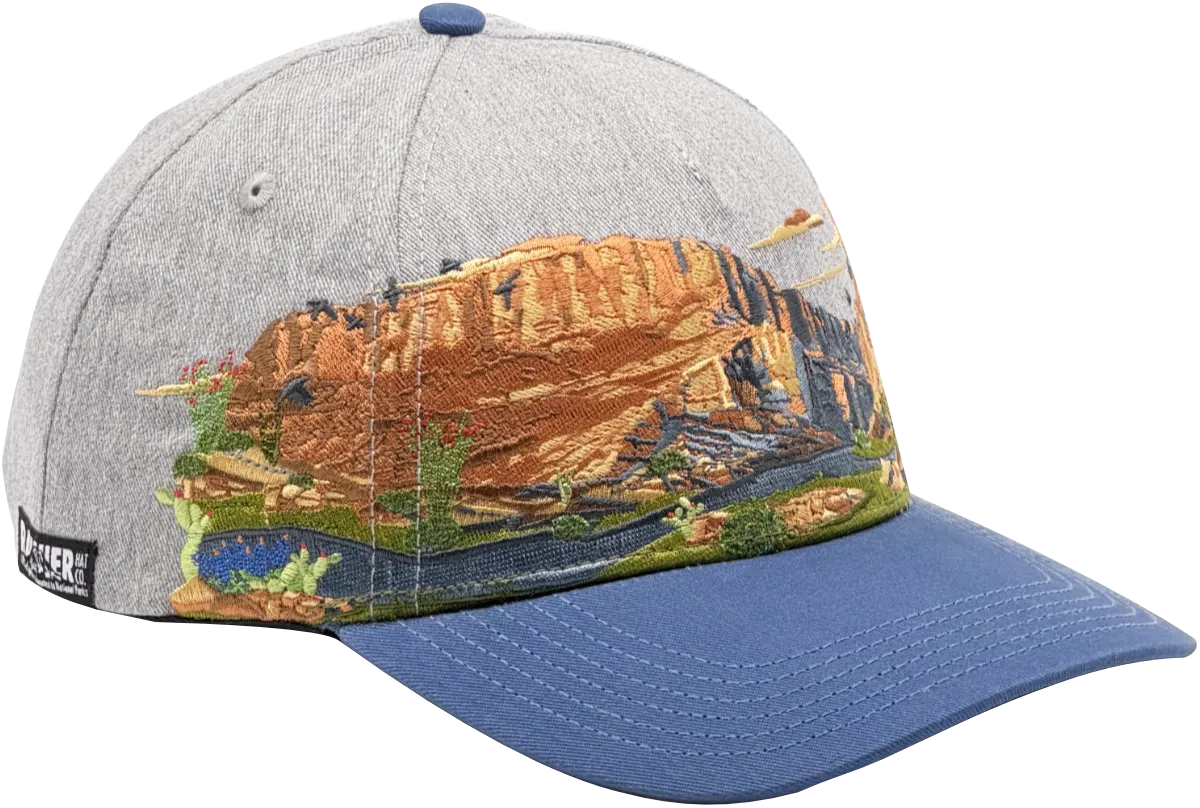
Protecting Big Bend
Big Bend National Park is the largest protected area of the Chihuahuan Desert in the United States, preserving a diversity of ecosystems and the species that depend on them. Santa Elena Canyon sits at the heart of that protection, where the Rio Grande cuts through limestone and sustains riparian habitat along an international boundary. Upstream dams, pollution, and invasive species have already degraded aquatic resources in the Big Bend region, and seven native fish species have been extirpated from the Rio Grande.
Despite its protected status, Big Bend faces real threats from climate change, invasive species, and habitat pressures that don't stop at park boundaries. Preserving Santa Elena Canyon means keeping these geological, biological, and cultural records intact so future generations can study, visit, and understand this landscape on its own terms.
Rainier Hat Co. exists to fund that work directly. We operate as a funding vehicle for the parks and 100% of profits from every hat go straight to National Parks conservation. When you pick up the Big Bend hat, you're not buying a souvenir. You're putting money into the places that make experiences like Santa Elena Canyon possible for everyone who comes after you.