Middle North Falls, Silver Falls State Park
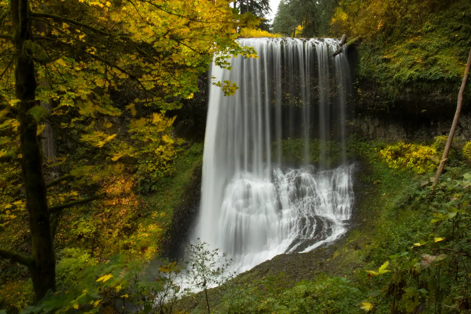
- Centuries of erosion carved a large grotto behind the 106 foot falls, and a trail runs through it so you can walk behind the curtain of water.
- The closest parking to Middle North Falls is the Winter Falls Trailhead, which puts you just 0.7 miles from the falls, though parking there is very limited.
- Silver Falls State Park sits on Highway 214 near Silverton, about 25 miles southeast of Salem. From I-5 exit 253 in Salem, drive 10 miles east on Highway 22, then turn left toward Silver Falls Park and follow Highway 214 for 16 miles to the park entrance.
- The park is open all year, but winter can bring ice, snow, and slick shaded trails. Water flows are strongest from late fall through spring and wildflowers bloom in spring.
- A short spur trail leads behind the wide curtain of water to a dead end on the other side. The trail is narrow and the falls broad enough that you will get wet.
North Fork Silver Creek drops 106 feet in a wide near vertical sheet before spreading across a dark basalt pool at the canyon floor. From the end of the spur trail behind the falls, you look back through a curtain of moving water at a canyon framed by Douglas fir, bigleaf maple, and the dark grey walls of a basalt grotto. In autumn, the maples turn yellow against the deep green of the conifers while the creek winds through the scene below.
The grotto itself is the widest of any walk behind waterfall in the park. Water, over centuries, eroded the softer rock beneath a thick basalt lava flow and carved out a natural alcove large enough to move around in. Look up and you'll see cylindrical holes in the basalt ceiling, left where ancient lava cooled around tree trunks that were growing here long before the rock arrived.
The sensory experience here is direct. The falls produce a constant low roar and push mist into the alcove, enough to dampen your jacket if you linger. The rock walls stay cool and dark, slick with water and patchy with moss. Out at the water's edge, belted kingfishers sometimes perch on the branches of streamside trees, scanning the creek below.
This is one of four waterfalls in Silver Falls State Park where a trail passes behind the water. The spur trail ends at the grotto, so the only way to see it is to commit to getting at least a little wet on the way in and out.
Getting to Middle North Falls
The closest parking to the falls is the Winter Falls Trailhead. From there follow the Winter Trail 0.5 miles down into the canyon to where it meets the Canyon Trail, then turn left and continue another 0.2 miles to the signed spur for Middle North Falls. That puts you at the water in just under a mile from your car.
Parking at Winter Falls is limited to a small number of spaces so arriving early helps, especially on weekends from spring through fall.
When to visit for the best light
The falls sit in a deep canyon and direct sunlight is rarely an issue even on clear days, which makes overcast skies ideal for even, workable light on the water and the dark basalt walls of the grotto. Fog and mist floating in the trees combined with wet leaves and rocks produce saturated colors that make early autumn mornings particularly good for photography.
Middle North Falls changes shape dramatically as water volume shifts through the year. The falls narrow to a column perhaps five feet wide in summer, funneled through a channel in the bedrock, then spread into a wide curtain again by late winter and spring. The park is open all year, but winter can bring ice, snow, and slick shaded trails. Water flows are strongest from late fall through spring, and wildflowers bloom in spring.
Three things worth looking for
Look up at the basalt ceiling inside the grotto. The cylindrical holes bored into the rock are molds left by trees that were growing here when ancient lava arrived and later eroded away leaving the voids behind. The intro to the park's geology is right above your head.
Large boulders decorated with moss and licorice fern line the creek along the approach trail and inside the grotto itself. The fern grows in dense patches on the wet rock faces and stays green year round.
Keep an eye on the branches of streamside trees near the pool at the base of the falls. Belted kingfishers perch along the creek and scan the water below, particularly in the quieter morning hours before foot traffic picks up on the Canyon Trail.
Insider Tips
Walk past the spur junction for the downstream view
Most visitors turn left at the signed spur and head straight into the grotto, which makes the short stretch of Canyon Trail continuing downstream surprisingly quiet. Walk 50 to 100 feet past the junction toward Drake Falls and turn back upstream. From there you frame the full curtain of water against the dark basalt canyon walls with the creek running toward you in the foreground.
This angle holds up especially well in fall when the bigleaf maples on the far bank turn yellow. You get the height of the falls, the canyon walls, and moving water in the same shot without anyone standing in your frame.
Wear waterproof footwear with grip
The basalt inside the grotto is wet and smooth and the trail narrows on the approach to the falls. Even on dry days the mist from the falls reaches the Canyon Trail proper. Waterproof hiking shoes or boots with a lugged sole give you solid footing where it counts.
Bring a packable rain layer too. The grotto pushes a steady mist onto anything you're wearing and if you spend time inside with a camera or just taking it in you will feel it accumulate. A shell you can stuff in your bag adds almost nothing to the carry.
Stop at Silverton Coffee Station on the drive in
Silverton is about 15 miles northwest of the park on Highway 214, on the route from Portland or Woodburn. Salem drivers can reach it with a short detour. Silverton Coffee Station operates out of a restored 1970s gas station on South Water Street and opens at 8 a.m. most days, early enough to caffeinate before you reach the trailhead.
They serve Allann Bros coffee roasted in Oregon and keep outdoor seating along Silver Creek. If you're targeting an early start at the park, time your drive to arrive when they open.
Nearby Hikes
Trails worth your time when you're in the area.
Trail of Ten Falls
The full loop follows Canyon Trail and Rim Trail along North Fork Silver Creek, passing ten waterfalls in a single circuit. Five of those falls top 100 feet and four have walk behind grottos, carved where water eroded softer rock beneath ancient basalt lava flows. Most hikers take three to five hours and the rolling terrain breaks up the elevation gain with waterfall stops throughout.
View on wta.orgSouth Falls and Maple Ridge Loop
The shortest loop in the park that still takes you behind a waterfall. Canyon Trail descends from the South Falls day-use area to 177-foot South Falls and continues to 93-foot Lower South Falls, with a walk behind trail at each. Maple Ridge Trail then climbs back out of the canyon on a series of switchbacks through second growth fir and bigleaf maple.
View on oregonhikers.orgWinter Falls Loop
A five-mile option that reaches seven of the park's ten waterfalls by shortcutting the full loop via Winter Trail near the canyon midpoint. The route still includes the walk behind grottos at South Falls, Lower South Falls, and Middle North Falls along with Drake Falls, Lower North Falls, Double Falls, and 134-foot Winter Falls on the canyon wall above.
View on oregontails.orgNorth Falls and Upper North Falls
From the North Falls Trailhead at the east end of the park, a short trail drops along North Fork Silver Creek to 136-foot North Falls, where the trail passes directly behind the falling water. Upper North Falls sits 0.3 miles upstream at 65 feet with a broad shallow pool and a flat streamside approach. Leashed dogs are allowed only on the short spur to Upper North Falls, not on the Canyon Trail section behind North Falls. That makes Upper North Falls one of the few dog friendly waterfall stops in the park.
View on pinesnvines.comNorth Rim Trail
A flat half-mile trail from the North Falls day-use area that ends at a fenced viewpoint above 136-foot North Falls. The trail stays on the canyon rim with no stairs or significant grade making it accessible for strollers and most mobility aids. Leashed dogs are welcome and a Nature Play Area near the trailhead adds a stop for families with young kids.
View on stateparks.oregon.gov
Protecting Silver Falls
The canyon at Middle North Falls exists today because people worked to protect it. A Silverton photographer, June Drake, led a decades long campaign to protect Silver Falls from logging companies, and the land that eventually became the park had already taken serious damage. The land around Silver Falls had been damaged by logging and farming and by two large fires in the 19th century, leaving a damaged watershed and many stumps where the forest now grows back.
Protecting old growth forest and the water quality of Silver Creek are the park's primary conservation priorities, and the park manages invasive species including English ivy, which can smother native understory plants. Stream bank erosion along heavily trafficked sections of the Trail of Ten Falls requires ongoing trail maintenance, and with more than a million visitors each year, the park faces significant challenges: litter thrown from overlooks, worn trails, and constant maintenance needs.
Funding that work isn't guaranteed. Budget challenges for the Oregon Parks and Recreation Department have postponed a planned campground addition at Silver Falls while also limiting some park programming, as OPRD faces a significant operations budget shortfall. Friends of Silver Falls, the nonprofit dedicated to preserving the natural and cultural resources of the park, helps bridge the gap through interpretive programs and project funding so future generations can enjoy the park as visitors do today.
Rainier Hat Co. is built around that same idea. We don't just sell hats. Each one is a funding vehicle for the parks, and 100% of the profit from the Silver Falls hat goes directly to the National Parks. Buying one isn't a souvenir purchase. It's a direct contribution to keeping places like Middle North Falls intact for the people who come here decades from now.