Denali: Stony Hill Overlook
GuidesDenali National Park: Stony Hill Overlook
The Ultimate Guide To

Stony Hill Overlook, Denali National Park

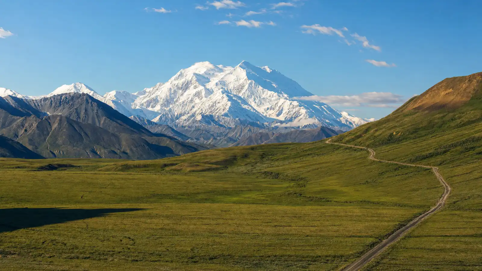
One of the clearest views of Denali rises from this open tundra ridge along the park road.

At a glance
  • Visit mid May through mid September, and aim for clear days: Denali is often hidden by summer cloud cover, so build flexibility into your schedule and be ready when the weather opens up.
  • Use a park bus when the road fully reopens: Stony Hill sits at mile 62 on the Park Road. In normal operations beyond Savage River, access is by park transit bus or narrated tour bus rather than private vehicle. For 2026, buses turn around at mile 43 and do not reach Stony Hill.
  • Road closure currently in effect: The Pretty Rocks Landslide has closed the Park Road at mile 43 and Stony Hill is not accessible until the road reopens, which is expected around 2027. Check the NPS website for updates before you plan your trip.
  • Take in the first full base to summit view of Denali: This is the first point along the road where the mountain appears without obstruction, roughly 37 miles to the southwest. No hiking required since the overlook sits right at the road.
  • Scan the open tundra for wildlife: Caribou, wolves from the Toklat pack, and migrating Sandhill Cranes all move through this area. The wide open alpine tundra gives long sightlines in every direction.

Stony Hill Overlook sits at mile 62 of the Denali Park Road, on an open ridge of alpine tundra where the treeline has long since given way to low sedge, lichen, and dwarf shrubs. The terrain spreads out in shades of olive, rust, and gold depending on the season, with the park road threading through the valley below toward the southwest.

On a clear day, Denali rises into full view from here, 37 miles away and unobscured by other peaks. This is the first base to summit view of North America's tallest peak along the park road, and the scale takes a moment to settle. The north peak appears nearly as tall as the higher south peak because it sits 1.5 miles closer, a straightforward matter of perspective at this distance.

The tundra around the overlook is low and open, which makes it good habitat for caribou. Trails worn into the slopes by seasonal migration are visible above the overlook, and Stony Hill is also a reliable place to watch for the nearby Toklat Wolf Pack. The overlook is also known for migrating birds, and arctic ground squirrels are nearly always present near the roadside.

Denali is visible only about 10 to 20 percent of the time, so most visits end with the peak hidden in cloud cover. When the clouds do clear, glacial ice on the upper flanks catches and holds light against a blue or grey sky. Dwarf fireweed blooms pink across the tundra in mid to late summer, adding color to a landscape that otherwise runs in muted greens and earth tones.

The Visit

Getting there

Stony Hill Overlook sits at mile 62 on the Park Road. Private vehicles are restricted to the first 15 miles of the Park Road during summer. During normal full road operations, visitors continue beyond Savage River by park transit bus or narrated tour bus, with Stony Hill served by buses that travel toward Eielson, Wonder Lake, or Kantishna. In 2026, those longer routes are not operating and no public bus reaches Stony Hill.

Check the NPS website for current road conditions before you go. A landslide near mile 45 has blocked vehicle traffic on the Park Road and the road is not expected to fully reopen until 2027.

Best season and time of day

The park is generally open from mid May through mid September. The overlook faces southwest toward Denali, so morning light works in your favor. Early morning and late evening often provide the best light and clearer views of Denali.

To be in the park during those optimum golden hour times, you nearly have to plan an overnight camping excursion. In August, sunrise falls between 5:45 and 5:55 am with sunset running from 10:20 to 10:30 pm. On average, persistent summer clouds hide the mountain from 70 percent of visitors, so patience matters as much as timing.

Small details worth noticing

From the overlook, the north peak at 19,470 feet appears approximately the same height as the taller south peak at 20,310 feet. This is a result of visual perspective since the north peak is 1.5 miles closer than the south peak. The north peak is capped with a sedimentary rock called Kahiltna Flysch, which formed in a deep oceanic basin approximately 100 million years ago and has since uplifted not only above sea level but to near the top of the highest peak on the continent.

The Stony Hill area is known for wolves and migrating birds. Keep an eye on the open tundra for caribou grazing through in summer and dwarf fireweed producing pink blooms through July and August. Visitors may also spot the Toklat Wolf Pack or migrating sandhill cranes.

Denali: Stony Hill Overlook
Find it

Denali: Stony Hill Overlook

Earned the hard way

Insider Tips

01

Leave the pullout behind

The transit buses stop right at the main overlook, and most riders stay within a few steps of the road. Walk 200 to 300 yards south along the open tundra away from the pullout and drop to a lower angle where dwarf birch and lichen fill the foreground with the park road curving toward Denali beyond.

You get the same mountain view with far less competition in the frame. The open tundra here has no formal trails, so you pick your own line.

02

Pack a windproof shell

Stony Hill sits on an exposed alpine ridge where wind moves across freely, even on sunny summer days when temperatures feel comfortable down at the park entrance. Bring a windproof shell you can pull on quickly, and wear waterproof trail runners or light hiking boots for the uneven tundra surface.

Temperatures can drop fast when a cloud moves in, so a base layer and mid layer are worth carrying even if you leave them in your pack all day.

03

Stop in Talkeetna at Conscious Coffee

Talkeetna is a 14-mile detour off the Parks Highway at Mile 98.7, roughly halfway between Anchorage and the park entrance and a natural place to break up the drive. Conscious Coffee is a small window service cafe on Main Street where locals and Denali bound climbers both fuel up in the morning.

The espresso is solid, the vibe is relaxed, and there is outdoor seating if you want to stretch your legs before the final push north.

Lace up

Nearby Hikes

Trails worth your time when you're in the area.

hard

Savage Alpine Trail

4 mi/1,500 ft gain

This 4 mile point to point trail connects Mountain Vista (Mile 13) and Savage River (Mile 15), gaining over 1,500 feet as it climbs through alpine tundra to a rocky ridgeline at around 4,000 feet. The steepest section concentrates in the first mile from the Savage River trailhead, where stone steps cut into rock give way to switchbacks. From the ridge, the Savage River valley and Alaska Range open to the west and on clear days Denali is visible in the distance. Dall sheep, caribou, and Arctic ground squirrels are frequently spotted along the upper sections. The free Savage River Shuttle connects both trailheads, making it practical to hike one way and skip the return trip.

View on earthtrekkers.com
hard

Mount Healy Overlook Trail

5.1 mi/1,712 ft gain

Starting from the Visitor Center parking lot, this out and back trail climbs steadily through boreal forest before opening onto exposed tundra in the upper miles. The grade steepens over the final stretch to the overlook at 3,530 feet, where the Nenana River Valley, Healy Ridge, and surrounding ridgelines spread in all directions. On a clear day, Denali is visible to the southwest. This trail gains more elevation than any other maintained route near the park entrance and offers the widest views you can reach on foot from the visitor center.

View on nps.gov
easy

Savage River Loop Trail

2.2 mi/200 ft gain

A 2.2 mile loop at Mile 15 of the Park Road that follows both banks of the Savage River through a narrow glacial canyon. A wooden footbridge at the midpoint crosses the river to complete the loop. The canyon walls funnel wind through the corridor year round, so bring an extra layer even on warm summer days. Dall sheep frequently appear on the canyon walls above and Arctic ground squirrels are active throughout the route. Parking here fills quickly since this trailhead marks the farthest point private vehicles can drive into the park.

View on nps.gov
easy

Horseshoe Lake Trail

2.2 mi/250 ft gain

A forested loop near the park entrance that drops to an oxbow lake formed by an old meander of the Nenana River. A bench overlook near the top provides a view of the lake before the trail descends steeply to the water, circles the shore through mixed spruce and birch, and climbs back to the trailhead. Moose feed in the shallows regularly and beavers are active along the edges. Early mornings are the best time to catch wildlife activity here before other hikers arrive.

View on nps.gov
easy

Mountain Vista Loop Trail

0.6 mi/50 ft gain

A short interpretive loop at Mile 13 of the Park Road set on open tundra with clear sightlines toward the Alaska Range. Signs along the route explain the area's geology and the history of early park visitors. On a clear day, Denali is visible from the trail. Accessible by car or the free Savage River Shuttle, this is a good first stop to get oriented to the landscape before heading farther into the park.

View on nps.gov
On the way

Denali National Park Hat

We're still working on this one. Get notified the moment it's ready — 100% of the profit goes straight to the National Parks.

Get notified
Denali National Park HatComing Soon
Why it matters

Protecting Denali

The alpine tundra at Stony Hill Overlook is under real ecological pressure. Rising temperatures favor taller denser vegetation, with taiga forest expected to shift northward and upslope, replacing tundra. As permafrost thaws beneath the surface, increased erosion, landslides, and sinking of the ground surface follow.

Tundra areas that caribou have relied on for foraging during the calving season would be reduced as these shifts continue. Denali also faces threats from human activity on many scales, including increased tourism and development, the introduction of exotic species, and accumulation of trace amounts of global airborne contaminants.

These changes accumulate slowly but their effects on plant communities, wildlife movement, and the broader sub arctic ecosystem are measurable and difficult to reverse. Denali is home to 39 species of mammals and 165 species of birds, along with more than 750 species of vascular plants — all of them dependent on the ecological conditions that this landscape currently provides. When open tundra converts to shrubland or forest, restoring that ecological foundation is not straightforward.

At Rainier Hat Co., we believe the parks need more than visits. Every hat we sell functions as a direct funding mechanism for the National Park Service, with 100% of profits donated back to the parks. The Denali hat is a way to put real dollars behind the conservation work happening at places like Stony Hill Overlook, so future generations can still find open tundra, clear air, and a full base to summit view of Denali rising above the Alaska Range.
Frequently Asked Questions

Where exactly is Stony Hill Overlook?

Stony Hill Overlook sits at mile 62 of the Denali Park Road, deep in the interior of Denali National Park. At roughly 3,960 feet (1,207 meters) in elevation, it occupies an open tundra ridge with unobstructed sight lines in multiple directions. The overlook is right alongside the road, so no hiking is required to take in the view.

Can I drive my own car to Stony Hill Overlook?

Private vehicles are only permitted on the first 15 miles of the Park Road, as far as the Savage River area. Beyond that point, access requires a park transit bus or a narrated tour bus. This vehicle restriction exists to protect the fragile tundra ecosystem along the 92 mile road corridor.

Is Stony Hill Overlook accessible by bus in 2026?

Not in 2026. The Pretty Rocks Landslide at mile 45.4 has kept the Park Road closed past mile 43 since 2021, and that closure remains in effect for the entire 2026 season. All transit and tour buses currently turn around at mile 43. Reaching Stony Hill on foot from the current turnaround involves a 19 mile one way hike through open backcountry terrain and requires a free backcountry permit from the Backcountry Information Center near the park entrance.

When will bus access to Stony Hill Overlook return?

A new steel bridge spanning the Pretty Rocks Landslide is under construction, but full bus service to Stony Hill and beyond is not expected to resume until 2027. Check the NPS website at nps.gov/dena and reservedenali.com for current updates, as timelines on large infrastructure projects in remote Alaska can shift.

What will I see from Stony Hill Overlook on a clear day?

The overlook offers the first unobstructed base to summit view of Denali as you travel west into the park. On clear days the mountain rises approximately 37 miles (60 km) to the southwest with no other peaks breaking the line of sight. The open tundra setting also provides wide views across the surrounding Alaska Range, and the Park Road curves toward the mountain in the foreground, giving the scene notable depth.

How likely am I to actually see Denali from the overlook?

Denali is often hidden by summer cloud cover, and many visitors never get a full summit view. Weather systems can cover the upper mountain even when lower elevations are clear. Many visitors see partial views or only the lower flanks, which still communicate the scale of the Alaska Range. Early morning departures often offer better odds before daily cloud buildup.

Why do Denali's north and south peaks look nearly the same height from Stony Hill?

The north peak stands at 19,470 feet (5,934 m) and the south peak reaches 20,310 feet (6,190 m), a real difference of 840 feet. From Stony Hill, the north peak appears nearly as tall because it sits about 1.5 miles (2.4 km) closer to the viewer. That difference in distance compresses the apparent height between the two summits into something close to equal.

What is the Kahiltna Flysch and why does it matter?

The Kahiltna Flysch is a sedimentary rock that caps Denali's north peak. It formed on the floor of a deep ocean basin roughly 100 million years ago during the Cretaceous Period and has since been lifted from sea level to nearly the top of the highest peak on the continent. The rock contains fossilized marine organisms, so mountaineers near the summit can encounter evidence of ancient ocean life while standing at the roof of North America.

Is Denali still growing?

Yes. The mountain rises at a rate of about one millimeter per year due to ongoing tectonic uplift. At that pace it will gain roughly one kilometer of additional height over the next million years, which counts as a brief span in geologic time.

What wildlife might I see at or near Stony Hill Overlook?

Caribou are common across the open tundra around the overlook. The Toklat Wolf Pack ranges through this territory and sightings occur with some regularity from the road. Sandhill Cranes pass through during migration and grizzly bears move across the surrounding terrain as well. Bring binoculars. Much of the wildlife moves at distances that are hard to appreciate with the naked eye.

What is the Toklat Wolf Pack?

The Toklat Wolf Pack is one of the most closely monitored wolf populations in Alaska, occupying a territory that includes the area around Stony Hill Overlook. Researchers have tracked the pack for decades, building a long term record of population dynamics and behavior in a largely roadless wilderness. Sightings from the overlook and the surrounding road corridor are reported regularly by bus passengers, particularly in early morning and evening.

Can I see Sandhill Cranes from Stony Hill Overlook?

Sandhill Cranes migrate through the Denali interior in late summer and fall, and Stony Hill Overlook is a known area for sightings during those windows. Timing matters: cranes are most likely to appear in August and September as they move south. They tend to move in groups and are recognizable both by their size and the distinctive rattling calls that carry across open tundra.

Which bus tours stop at Stony Hill Overlook when the road is fully open?

The Tundra Wilderness Tour, a narrated 7 to 8 hour trip led by a driver naturalist, turns around at Stony Hill before returning to the park entrance. Transit buses headed to Eielson Visitor Center, Wonder Lake, or Kantishna also stop here on request. The Toklat River transit bus turns around before reaching mile 62 and does not serve the overlook.

What is the difference between a transit bus and a tour bus at Denali?

Transit buses are non narrated, green colored, and operate on a hop on hop off basis once you leave the paved section of road. They cost less and give you more flexibility to get on and off along the route. Tour buses are tan colored and include a driver naturalist who provides interpretation throughout the trip. Both types stop for wildlife when conditions allow.

How do I reserve a park bus ticket?

Tickets are available at reservedenali.com. Reservations are strongly recommended because seats fill quickly during peak summer months. Once you arrive at the park, bring your confirmation to the Denali Bus Depot to pick up your physical ticket and pay the entrance fee. Plan to arrive at least 20 minutes before your departure time.

What does the park entrance fee cost?

The standard entrance fee is $15 per adult and is not included in the bus ticket price. You pay it when you collect your ticket at the Denali Bus Depot. Visitors with a valid America the Beautiful National Parks Pass can present it at the depot to waive the entrance fee entirely.

Should I bring food and water on the bus?

Yes, and plan for the full round trip duration. No food or water is available for purchase once the bus is underway, and a trip to Stony Hill and back can run seven hours or more. The Eielson Visitor Center at mile 66 has a water refill station for routes that extend that far. Food and coffee are available at the Denali Bus Depot before departure.

Are restrooms available at Stony Hill Overlook?

There are no restrooms at the overlook itself. Transit buses make scheduled restroom stops roughly every 60 to 90 minutes along the route, and vault toilets are available at several stops. For a full day bus trip, plan accordingly and communicate with your driver if you have specific needs along the route.

Is Stony Hill Overlook accessible for visitors of all ages and mobility levels?

The overlook sits directly along the road with no hiking required, making it workable for a wide range of visitors including young children and those with limited mobility. Wheelchair accessible buses operate on designated schedules, so check the posted timetable at reservedenali.com to identify those specific departures. Note that the bus ride itself is long and the road beyond mile 15 is unpaved, so expect some bumps along the way.

Can I get off the bus at Stony Hill and explore on foot?

Yes. Transit bus passengers can disembark at any point along the route after leaving the paved section and then wave down a passing bus to continue or return. The open tundra around Stony Hill is part of backcountry unit 33, where off trail travel is permitted. If you plan to stay overnight in the backcountry, you need a free permit from the Backcountry Information Center near the park entrance. Day use with a same day bus return requires no permit.

What time of year is Stony Hill Overlook accessible?

Bus service along the Park Road typically runs from late May through early September, depending on snow conditions each year. Outside that window, deep snow and road conditions make the route inaccessible to buses. Early September can still offer clear mountain views along with tundra turning yellow and red as fall sets in, and wildlife activity often increases as animals prepare for winter.

What gear should I bring for a day trip to Stony Hill Overlook?

Dress in layers. Temperatures at nearly 4,000 feet shift quickly even in midsummer and mornings can be cold even when afternoons warm up. Rain gear is essential since weather changes fast across open tundra terrain. Binoculars are worth the pack space for both wildlife spotting and reading the detail of Denali's ridges and glacier faces at 37 miles. Bring enough food and water for the full duration of your chosen bus route.

What caused the Pretty Rocks Landslide that has blocked road access?

The landslide at mile 45.4 is driven by thawing permafrost beneath the road surface. As permafrost warms, the ice rich soil loses its structural integrity and the ground flows downhill. The slide has been active since at least the 1960s but accelerated sharply after 2014 and by 2021 was moving fast enough that road maintenance became unsafe. The National Park Service is constructing a permanent steel bridge to span the slide zone, with full bus service expected to resume in 2027.

Is Stony Hill Overlook good for photography?

The overlook works well for wide compositions because the Park Road curves toward Denali in the foreground, creating a natural leading line toward the mountain. Morning light tends to fall on the south face before clouds build over the summit later in the day. A telephoto lens helps pull in detail on the upper ridges and glacier faces from 37 miles out. Overcast days, while not ideal for the summit, can produce even, diffused light across the tundra.

Are there any ranger programs or interpretive services at Stony Hill Overlook?

Stony Hill Overlook itself does not have a staffed ranger station or scheduled ranger programs. Interpretation at this stop comes from driver naturalists on narrated tour buses who provide context on the geology, ecology, and wildlife of the area during the journey. The nearest full visitor center with ranger programs is Eielson Visitor Center at mile 66, which offers daily ranger led tundra walks during the summer season when access is open.